The Weather component is the main component of the kit, it provides weather data and allows the SunPosition and MoonPosition components to work properly. The component is based on the Open Weather Map Service (available at: https://openweathermap.org), so for proper work the controller must be connected to the Internet. The Open Weather Map Service is free for a basic use–up to 60 requests per minute or up to 1.000.000 requests per month. In case the number of devices in use implies higher number of requests per minute or per month, the Open Weather Map Service offers paid subscription plans (available at: https://openweathermap.org/price).
In order to enable the Weather kit components, an Open Weather Map Service API key is necessary. To receive the API key, create an account on the Open Weather Map Service (https://home.openweathermap.org/users/sign_up), and go to the API keys tab. The default API key is generated up to two hours after a first sign-in, and more individual keys can be generated afterwards.
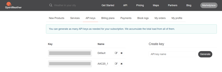
The Open Weather Map service view
Once the API key is generated, it has to be entered in the API key slot in the Weather component.
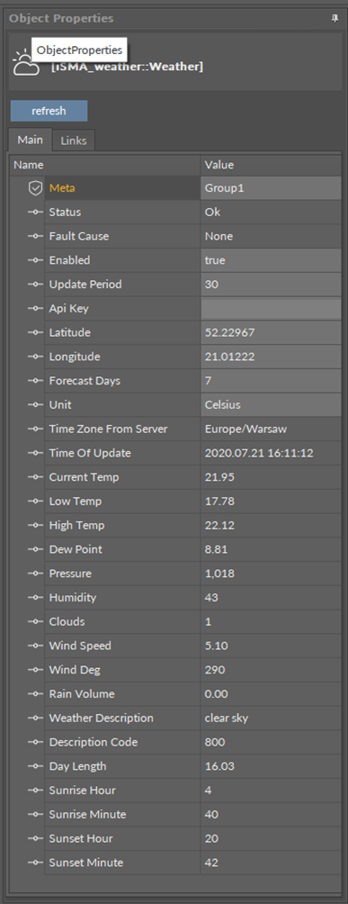
Weather component
The Weather component has the following slots:
-
Status: shows the component’s status;
-
Available information: OK (the component is working properly), Disabled (the component is disabled, the Enable slot is set to false), Discovering (the component is refreshing its data and downloading new data from the server);
-
-
Fault Cause: shows a description of a fault cause that occurred in the component;
-
Enabled: change of the slot's value enables or disables the component—if the component becomes disabled, it stops to read values from the server;
Note: By default, the component is disabled. In order to work properly, it needs to be enabled manually.
-
Update Period: time after which the weather data are refreshed (expressed in minutes);
-
Api Key: the API key generated from the Open Weather Maps Service;
-
Latitude: geographical latitude; geographic coordinates define the place which the component shows the weather conditions for;
-
Longitude: geographical longitude; geographic coordinates define the place which the component shows the weather conditions for;
-
Forecast Days: allows to set a number of days for the weather forecast;
Note: Smaller number of the forecast days means less time for the controller to process data.
-
Unit: allows to set a measured temperature units (Celsius of Fahrenheit);
-
Time Zone From Server: shows the time zone name of the place defined by geographical coordinates;
-
Time Of Update: shows the date and time of the last update from the server;
-
Current Temp: shows the current temperature in the place defined by geographical coordinates;
-
Low Temp: shows the minimum temperature for the day in the place defined by geographical coordinates;
-
High Temp: shows the maximum temperature for the day in the place defined by geographical coordinates;
-
Dew Point: shows the dew point temperature for the place defined by geographical coordinates;
-
Pressure: shows the pressure value for the place defined by geographical coordinates (expressed in hPa);
-
Humidity: shows the humidity value for the place defined by geographical coordinates (expressed in percentage);
-
Clouds: shows the cloud cover for the place defined by geographical coordinates (expressed in percentage);
-
Wind Speed: shows the wind speed in the place defined by geographical coordinates (expressed in meters per second);
-
Wind Deg: shows the wind direction in the place defined by geographical coordinates (expressed in degrees);
-
Rain Volume: shows the rain volume in the place defined by geographical coordinates (expressed in mm);
-
Weather Description: shows a text descriptor summarizing current weather conditions;
-
Description Code: shows a weather description code according to the list available at https://openweathermap.org/weather-conditions;
-
Day Length: shows the current day length in the place defined by geographical coordinates (expressed in hours);
-
Sunrise Hour: together with the Sunrise Minute value shows the time of sunrise in the place defined by geographical coordinates (expressed in HH:MM format, here shows the HH value);
-
Sunrise Minute: together with the Sunrise Hour value shows the time of sunrise in the place defined by geographical coordinates (expressed in HH:MM format, here shows the MM value);
-
Sunset Hour: together with the Sunset Minute value shows the time of sunset in the place defined by geographical coordinates (expressed in HH:MM format, here shows the HH value);
-
Sunset Minute: together with the Sunset Hour value shows the time of sunset in the place defined by geographical coordinates (expressed in HH:MM format, here shows the MM value).
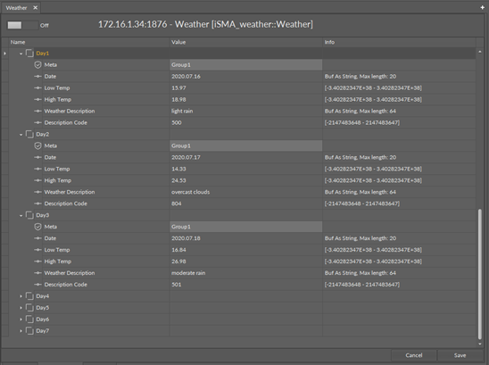
Day 0-7 components view
The Weather component also receives weather the weather forecast for next 0 to 7 days.
Day 0-7 components have the following slots:
-
Date: shows the date/timestamp of the weather report;
-
Low Temp: shows the minimum temperature for the day of forecast in the place defined by geographical coordinates;
-
High Temp: shows the maximum temperature for the day of forecast in the place defined by geographical coordinates;
-
Weather Description: shows a text descriptor summarizing weather conditions for the day of forecast in the place defined by geographical coordinates;
-
Description Code: shows a weather description code according to the list available at https://openweathermap.org/weather-conditions.
The Weather component has an available action:
-
Refresh: allows to manually refresh the data downloaded from the server.